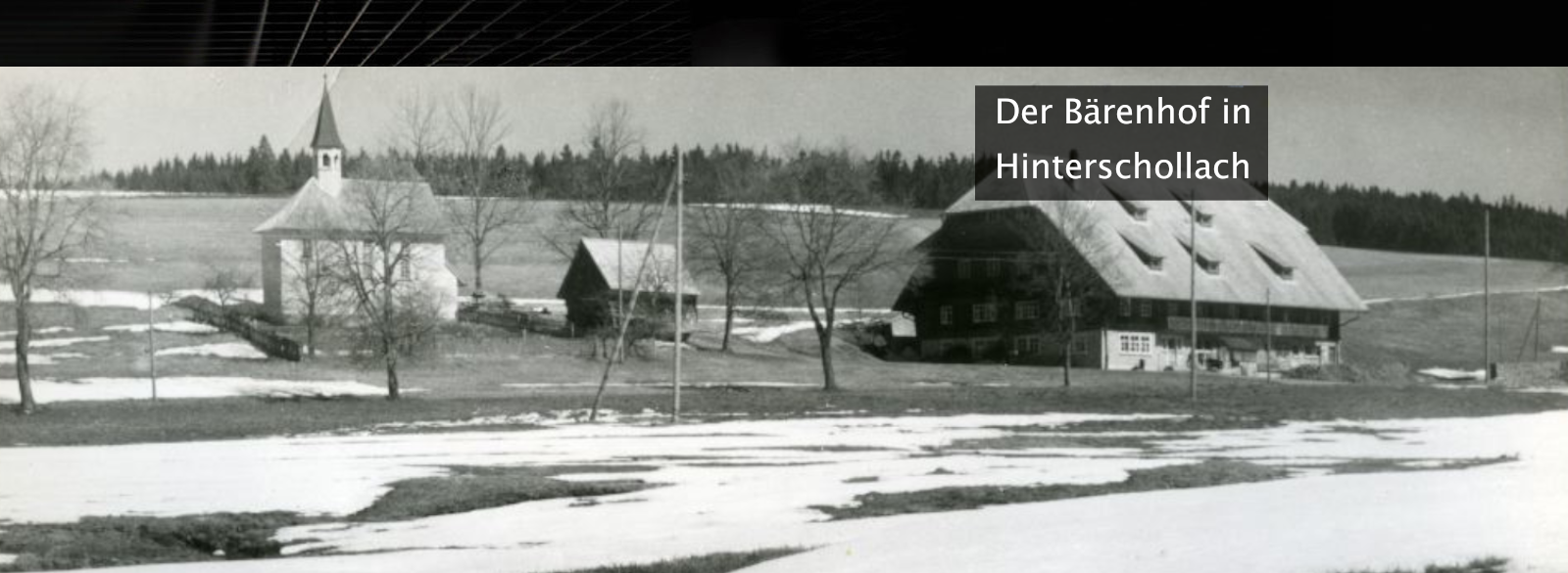


Simonswald


| Regionalauswahl: | |
|---|---|
| Typauswahl: | Gemeinde |
| Status: | Gemeinde |
| Homepage: | http://www.simonswald.de |
| service-bw: | Informationen zu wichtigen Adressen, Nummern und Öffnungszeiten in Simonswald |
| Einwohner: | 3009 |
| Bevölkerungsdichte (EW/km²): | 40.0 |
| Max. Höhe ü. NN (m): | 1228.14 |
| Min. Höhe ü. NN (m): | 311.54 |
| PLZ: | 79263 |
Visitenkarte
Ortsteile
Teilort
Wohnplatz
- Breilerhof - Wohnplatz
- Brennerhaldenhof - Wohnplatz
- Brennerhof - Wohnplatz
- Breuelhof - Wohnplatz
- Bruggerhof - Wohnplatz
- Christisbauernhof - Wohnplatz
- Elme - Wohnplatz
- Emmlerhof - Wohnplatz
- Eschenfirst(hof) - Wohnplatz
- Ettersbach - Wohnplatz
- Fallerhof - Wohnplatz
- Farnhof - Wohnplatz
- Fehrenbachshof - Wohnplatz
- Felsenbauernhof - Wohnplatz
- Felsenhäusle - Wohnplatz
- Gallibauernhof - Wohnplatz
- Ganterhof - Wohnplatz
- Gasse - Wohnplatz
- Gereuthof - Wohnplatz
- Gernhansenhof - Wohnplatz
- Grün - Wohnplatz
- Gutenhof - Wohnplatz
- Haldenbauernhof - Wohnplatz
- Haldenhof - Wohnplatz
- Haldenlenz - Wohnplatz
- Haldenschwarz - Wohnplatz
- Hanover - Wohnplatz
- Herrengraben - Wohnplatz
- Hintereck - Wohnplatz
- Hintergriesbach - Wohnplatz
- Hinterhaslach - Wohnplatz
- Hofbauernhof - Wohnplatz
- Hogenhof - Wohnplatz
- Holzschlag - Wohnplatz
- Hornhäusle - Wohnplatz
- Hugenhof - Wohnplatz
- Hüttenbauernhof - Wohnplatz
- Ibendörfle - Wohnplatz
- Ibichhof - Wohnplatz
- Ibich - Wohnplatz
- In der Erle - Wohnplatz
- Jockelehof - Wohnplatz
- Josenhof - Wohnplatz
- Kaltenbachhof - Wohnplatz
- Kandelhof - Wohnplatz
- Kasperhof - Wohnplatz
- Kostgefäll - Wohnplatz
- Langeckerhof - Wohnplatz
- Lochbauernhof - Wohnplatz
- Luxenhäusle - Wohnplatz
- Luxenhof - Wohnplatz
- Markenbauernhäusle - Wohnplatz
- Markenhof - Wohnplatz
- Martinsbauernhof - Wohnplatz
- Marxenbauernhof - Wohnplatz
- Mattenhof - Wohnplatz
- Metzgerhäusle - Wohnplatz
- Mittelhaslach - Wohnplatz
- Moosbauernhof - Wohnplatz
- Neuenberg - Wohnplatz
- Neuenweg - Wohnplatz
- Niederbrücke - Wohnplatz
- Nonnenbach - Wohnplatz
- Oberberg - Wohnplatz
- Oberdörfle - Wohnplatz
- Oberer Felsen - Wohnplatz
- Obernonnenbachhof - Wohnplatz
- Obertal - Wohnplatz
- Pfaffmühle - Wohnplatz
- Plattenhäusle - Wohnplatz
- Plattenhof - Wohnplatz
- Plattenhöfe - Wohnplatz
- Riederhof - Wohnplatz
- Röschbauernhof - Wohnplatz
- Saulache - Wohnplatz
- Scheiben - Wohnplatz
- Schlemperhof - Wohnplatz
- Schlemperhof - Wohnplatz
- Schlemperseppenhof - Wohnplatz
- Schurtenhof - Wohnplatz
- Schwanenwirtshof - Wohnplatz
- Siegelhof - Wohnplatz
- Siegel- und Wälderhof - Wohnplatz
- Simonshof - Wohnplatz
- Stegenhof - Wohnplatz
- Steinweidenhof - Wohnplatz
- Stoffelhof - Wohnplatz
- Streifershäusle - Wohnplatz
- Stubenbauernhof - Wohnplatz
- Uhrmacherhäusle - Wohnplatz
- Unterberg - Wohnplatz
- Unter der Linde - Wohnplatz
- Unterdörfle - Wohnplatz
- Untere Gfällhof - Wohnplatz
- Unterer Felsen - Wohnplatz
- Vitenhof - Wohnplatz
- Vitstinerhof - Wohnplatz
- Vogtshof - Wohnplatz
- Vogtshof - Wohnplatz
- Vorderer Dorerhof - Wohnplatz
- Vordergriesbach - Wohnplatz
- Vorderhaslach - Wohnplatz
- Vögtle - Wohnplatz
- Wahlenhof - Wohnplatz
- Waldvogelhof - Wohnplatz
- Wanglerhof - Wohnplatz
- Wasserhäusle - Wohnplatz
- Wälderhof - Wohnplatz
- Weberhäusle - Wohnplatz
- Wehrlebauernhof - Wohnplatz
- Wehrlehof - Wohnplatz
- Wehrlehof - Wohnplatz
- Wehrlemartinshof - Wohnplatz
- Wehrleshof - Wohnplatz
- Weisbauernhof - Wohnplatz
- Weishansenhof - Wohnplatz
- Willmes - Wohnplatz
- Winterbauernhäusle - Wohnplatz
- Winterhalden - Wohnplatz
- Wistiesenhof - Wohnplatz
- Wolfhof - Wohnplatz
aufgegangener Ort
Wüstung
Topographie
Statistiken


Wappen
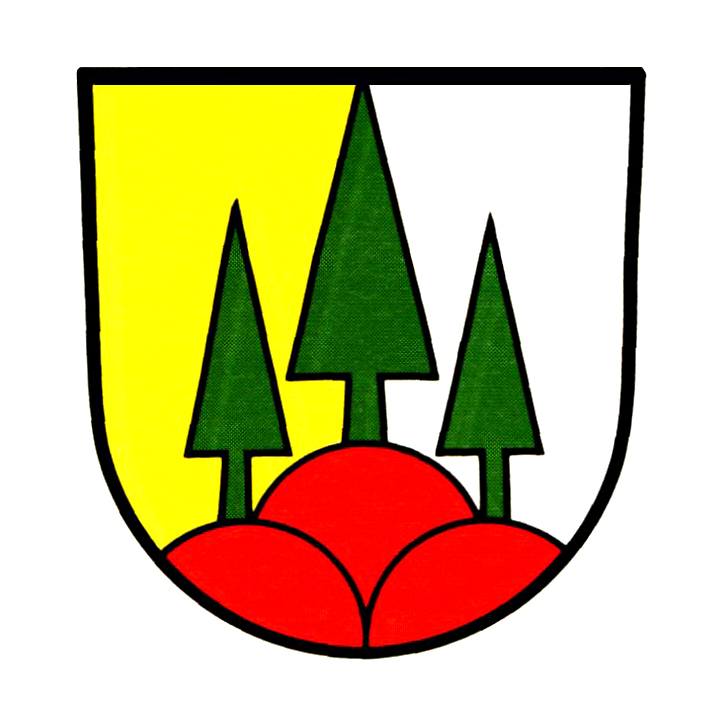
In von Gold (Gelb) und Silber (Weiß) gespaltenem Schild auf rotem Dreiberg drei grüne Tannen, von denen die mittlere, den Schild spaltend, bis zum oberen Schildrand reicht.
Beschreibung Wappen
Die Gemeinde entstand am 1. April 1970 durch Zusammenschluss von Altsimonswald, Haslachsimonswald und Untersimonswald. Knapp vier Jahre später wurden Obersimonswald und Wildgutach eingemeindet. Das Gemeindegebiet ist zu zwei Dritteln mit Wald bedeckt. Auf den Waldreichtum und den Ortsnamen der Schwarzwaldgemeinde weisen die Tannen im Wappen hin. Tannen hatten drei Ortsteile bereits in ihren Wappen geführt. Der Dreiberg, bisher im Gemeindewappen von Haslachsimonswald vertreten, kann als Hinweis auf die Gebirgslage verstanden werden. Die Farbkombinationen des Dreibergs und der Felder Rot-Gold und Rot-Silber erinnern an die badischen und österreichischen Farben. Alle Ortsteile gehörten zum vorderösterreichischen Breisgau und fielen 1805 an Baden. Wappen und Flagge wurden am 23. Februar 1972 vom Innenministerium verliehen.

Verknüpfte Inhalte
- Orte (140)
- Personen (11)
- Objekte (157)
- Themen (0)
Teilen
 leobw
leobw